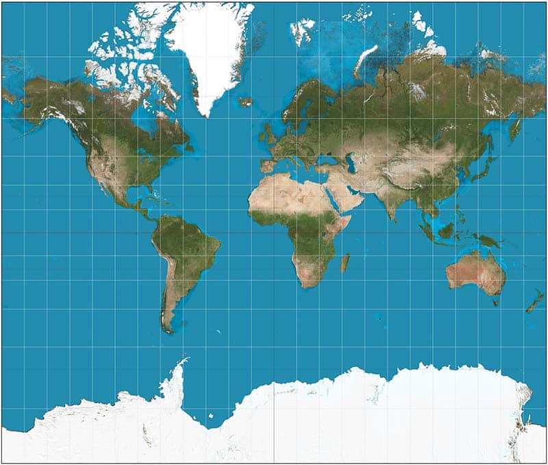
On September 4, 2026, the United Nations General Assembly adopted a resolution calling for more equitable cartographic representations of the world, particularly the representation of Africa. The resolution, titled “Correct the Map: Rebalancing Global Cartographic Representation and Promoting Equitable Representation of the World’s Regions, Particularly Africa,” was introduced by Togo on behalf of the African Group and backed by the African Union.
A total of 164 countries voted in favour, one against and six abstained. The resolution does not ban the Mercator projection or legally require countries and institutions to replace it. It encourages governments, schools, international organizations, media and technology companies to use equal-area projections, including the Equal Earth projection, when the relative size of regions matters.
The map that made Africa look smaller
The Mercator projection was created in 1569 by Flemish cartographer Gerardus Mercator, primarily as a tool for maritime navigation. Its great advantage was that it preserved angles and directions, making it useful for sailors navigating across the globe.
But the projection comes with a significant distortion: areas become increasingly exaggerated as they move away from the Equator.
The result is familiar to generations of students around the world. Greenland can appear comparable in size to Africa on a Mercator map, even though Africa is approximately 14 times larger. The problem, therefore, is not that the Mercator projection is “wrong” in every sense. It was designed for a specific purpose and remains useful for navigation.
The problem arises when a projection designed for navigation becomes the default visual representation through which generations learn to understand the relative size of the world’s continents.
Why does Africa want to correct the map?
The #CorrectTheMap campaign was launched by Africa No Filter and Speak Up Africa, organizations that have made narrative change and the representation of Africa central to their work. The African Union subsequently endorsed the campaign, while Togo took the diplomatic lead in bringing the issue to the United Nations.
Africa No Filter’s argument is straightforward: Africa does not need to be made bigger. It needs to be represented accurately. And that distinction matters.
For generations, Africans and the rest of the world have grown up looking at a map in which the continent appears significantly smaller than its actual landmass. Correcting that image does not solve poverty, conflict, inequality, climate change or any of the other challenges facing the continent, but it challenges a visual narrative that has been normalized for centuries.
For an older generation, the map can become a reminder of how easily a representation can be accepted as reality simply because it is repeated often enough.
For a younger generation growing up in the age of social media, digital storytelling and instant access to information, the correction offers an opportunity to question inherited narratives and circulate more accurate ones.
And perhaps the most important impact will be on generations that have not yet been born.
Imagine a child learning geography in a classroom where Africa is consistently represented according to its actual relative size. Imagine that child growing up without first having to unlearn the visual impression that Africa is somehow smaller, less significant or peripheral to the rest of the world.
The map beyond a tool is also a conversation starter. If we can question the way Africa has been represented geographically, what other representations have we accepted without questioning?
What does a new map actually mean for Africa?
There have understandably been questions about the significance of the initiative.
A different map will not build hospitals. It will not create jobs. It will not resolve conflicts. It will not address debt, inequality or the continent’s development challenges. It matters because representation is also a form of power.
Soft diplomacy is often associated with culture, politics, values, storytelling and the ability to shape perceptions. But it can also begin with something as seemingly ordinary as deciding how a continent is represented.
The diplomatic process behind #CorrectTheMap is therefore perhaps as important as the map itself. It was that an African-led narrative entered a global institution, generated a debate and received an overwhelming majority of support.
That is soft diplomacy in action. Not diplomacy through confrontation, but diplomacy through persistence, coalition-building, advocacy and the power of an idea.
The significance of #CorrectTheMap may ultimately lie beyond cartography.
For Africa, the campaign offers an example of what can happen when countries, institutions, civil society and storytellers converge around a common narrative. The continent is often discussed through statistics: poverty rates, conflict figures, humanitarian needs, development indicators and economic challenges. A voice does not become powerful only when the world agrees with it.
It becomes powerful when the world has to listen to it. If Africa can challenge the map that generations have accepted as normal, what other narratives are waiting to be questioned?
Deborah Ndjerareou
Image credit: Wikimedia/Daniel R. Strebe


Leave a comment